
New River-routing Model Improves Simulations of Water Movement within the Earth’s system
A new river-routing model improves computer simulations of the magnitude and timing of water flow through the landscape and into the ocean, thanks to the work of a research team led by Dr. Ruby Leung at Pacific Northwest National Laboratory. Designed to work in tandem with land and earth systems models, this new tool is better at simulating water flow at different scales than some widely used large-scale routing models. The model also can simulate river dynamics, including variations in depth and the velocity of river flow.
In this study, PNNL researchers developed the MOdel for Scale Adaptive River Transport (MOSART), a new large-scale river routing model. MOSART improves the magnitude and timing of river flow simulations and provides a framework for studying the influence of dams and reservoirs for water management decision-making. The research developed and tested a new physically-based river routing model that improves simulations of river flow over the Pacific Northwest region, thus supporting better water management decision-making.
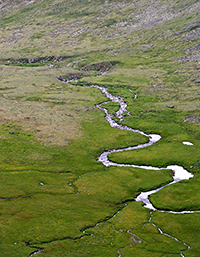
The team applied MOSART across local, regional and global scales with explicit treatment of sub-grid and in-channel water flow and dynamics. Designed to work within each spatial model grid unit, they tracked surface water runoff, first routed across ground surfaces, and then discharged along with subsurface runoff into a “tributary sub-network” before entering the main river channel. The spatial units are thus linked via routing through the main channel network, which is constructed in a consistent way across different spatial resolutions. All model parameters are physically based, and only a small subset requires calibration.
The team tested MOSART on a large river basin at different spatial resolutions and evaluated their model output using observed streamflow measurements from stream gauge stations. MOSART was compared to two other routing models used with land surface models. Their results compared well with consistent performance at multiple resolutions.
Additional model evaluations used channel velocities from field measurements or a hydraulic model at various locations. These results showed MOSART could produce seasonal variation and channel velocity magnitudes at different resolutions.
Water is essential for households, power generation and agriculture. Resource managers need tools to understand how water flows through the landscape, especially as water availability is affected by climate change. Scientists tackled a new way to model how water travels through and on the landscape and joined their simulations with established land and Earth system models to better understand a wide range of water-land interactions. The model serves as a cornerstone for integrating and understanding impacts of human activities, such as irrigation and reservoir operation, on the water cycle at a regional or global scale.
DOE scientists, working at the Pacific Northwest National Laboratory, found that a new physically based river routing model performs generally better than other extensively used large scale routing models. They developed the Model for Scale Adaptive River Transport (MOSART) for coupling with land surface and earth system models across local, regional and global scales. With a scale-consistent structure representing subgrid and channel routing, they evaluated MOSART at multiple spatial resolutions using streamflow and channel velocity measurements from the U.S. Geological Survey. MOSART outperformed models such as the River Transport Model (RTM), currently used in the Community Land Model (CLM). Compared to many other existing large scale routing models, MOSART is able to realistically simulate the in-channel dynamics including variations of water depth and velocity.
With relaxed assumptions of stationarity, MOSART may be more suited for modeling long-term climate change impacts than models that are more empirically based or require calibration. It provides a flexible framework for modeling terrestrial fluxes into the ocean for complete linkages across the atmosphere, land, and ocean components in earth system models. MOSART also serves as a cornerstone for integrating the human and earth system components of the water cycle. For example, MOSART has been coupled with CLM and a water resource management model to represent the effects of reservoir operations on the local and regional water cycle. Extending such capabilities globally will allow the local to global impacts of water management be represented in earth system models for predicting the evolution of the coupled system.
U.S. Department of Energy (DOE) Office of Science Biological and Environmental Research (OBER) Earth System Modeling (ESM) and Integrated Assessment Research (IARP) Programs through the Integrated Earth System Modeling (iESM) and Climate Science for Sustainable Energy Future (CSSEF) projects. Development of the datasets used in this study was partially supported by the PNNL Platform for Regional Integrated Modeling and Analysis (PRIMA) initiative.