
COMPASS-GLM: Coastal Observations, Mechanisms, and Predictions Across Systems and Scales, Great Lakes Modeling
Project Team
Principal Investigator
Co-Principal Investigator
Task / Institutional Lead
Project Participant
The Coastal Observations, Mechanisms, and Predictions Across Systems and Scales – Great Lakes Modeling (COMPASS-GLM) project is focused on developing a fully coupled regional earth system model centered around the Portage River basin in northern Ohio. The COMPASS-GLM pilot study aims to enhance predictive understanding of freshwater coastal systems, especially how they respond to climate warming, Land Use Land Cover Change (LULCC), and other perturbations at watershed-to-regional scales, and how these changes interact with and impact human systems. This includes, for example, local climate and weather feedbacks due to atmosphere lake interactions, lake breeze effects modulating urban heat island associated heat stresses, and climate mitigation strategies for farming.
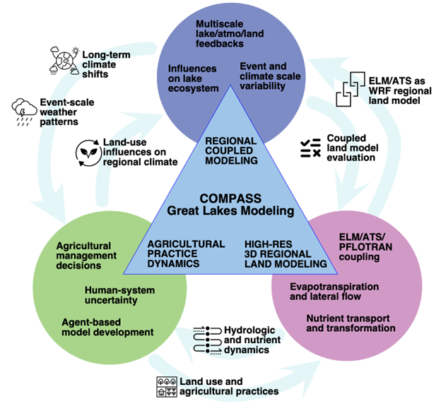
We are focusing on three tasks during our pilot study (see Figure 1): Regional Coupled Modeling, High-resolution 3D Regional Land Modeling, and Agricultural Dynamics. These tasks are tightly coupled, and together focus on answering these overarching long-term science questions:
- How do coastal systems respond to natural and anthropogenic influences?
- What multiscale mechanisms govern the structure, function, and dynamics of coastal systems at different spatial and temporal scales?
- Which processes are the most important to resolve to understand coastal systems in the context of climate change?
- What are the most effective ways to incorporate critical small scale processes in global earth system models that cannot resolve these processes?
- How do we best generalize new process knowledge and predictive skill gained at a small number of sites or regions across the observed diversity of coastal systems?
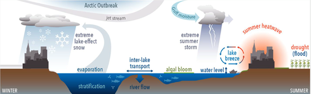
In the Great Lakes region, previous studies have already identified a number of processes, occurring at a wide range of scales from city to continental, that impact both human and natural systems. Figure 2 illustrates some of these important processes in the Great Lakes region.
Expected outcomes of the pilot study include:
- A flexible, integrated, and well-tested WRF+FVCOM modeling system that has multiple land surface, dimensionality, and resolution options will be developed. Model output from multiple scenarios and configurations, at a scales ranging from watershed to the entire Great Lakes region, will be archived and shared with the broader scientific community and can be leveraged by other agencies and groups to inform regional decision-making.
- Improved understanding of coupled processes and interactions that occur at sub-regional scales will be used to develop multiple peer-reviewed publications and to inform development of E3SM and other modeling systems. Improved methodologies for representing high-resolution watershed and lake processes within E3SM at regionally refined scales will be incorporated into the E3SM framework.
- An assessment of changing farming practice impacts on the regional ecosystem, climate change impacts on farming communities, and the effectiveness of various climate mitigation strategies will be performed to identify the most impactful regional climate signals and the most effective response strategies.